


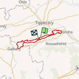
Slievenamuck Walking Marathon Sunday March 24th 2013

mlmoroneybb
User


11h36
Difficulty : Difficult

FREE GPS app for hiking
 SityTrail
IGN / Geographical institutes
SityTrail Plus
The world is yours!
About
Trail Walking of 42 km to be discovered at Unknown, County Tipperary, The Municipal District of Cahir — Cashel. This trail is proposed by mlmoroneybb.
Description
This very successful walking marathon, held annually on Palm Sunday and now in its fourth year, provides a unique opportunity to traverse the whole of this ancient Ridge over 42km. Geologically, a fragment of the Galtee mountains, Slievenamuck, or Hill of the Pig, derives its name from the feats of Finn MacCumhall who, in days of yore, speared the vicious sow, Beo, thus liberating the good people of the Glen of Aherlow.


Positioning
Comments